The Roads · 1848 – 1894
Chicago's Plank Roads —
Or Being Stuck in the Mud
Before Chicago had paved streets, farmers bringing goods to market sank axle-deep in spring mud. The solution was the plank road — "the farmer's railroad." And the man who turned it into a monopoly was Amos J. Snell.
Source: Chicago & Cook County Cemeteries — Barry A. Fleig, 2024
The Problem
Axle-Deep in Spring Mud
Back in the day, if you were a farmer bringing your goods into the city to sell, your horse and wagon would often sink deep into muddy rutted roads. This was especially true during the spring snow melt and torrential summer rains.
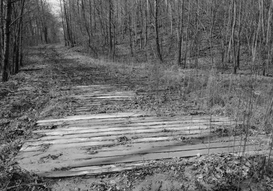
The solution was the plank road — often called "the farmer's railroad." Heavy planks a few inches thick and eight feet long, attached crosswise to wooden stringers set into the roadbed. Pine and hemlock were sometimes used, but oak and black walnut, though more expensive, were more durable. Fifty miles were built between 1848 and 1855 at a cost of approximately $150,000.
The Construction
"Plank roads were so rough that they were often called 'corduroy roads.'"
Chicago's Plank Roads — A Complete Map
Radiating Out of the City
Southwest Plank Road
Opened September 1848
Ogden Avenue → Lyons → Hinsdale → 22 miles
One of the first plank roads, it bridged the "nine-mile swamp" along what is now Ogden Avenue. Extended to Brush Hill and Fullersburg (now Hinsdale) in 1850, then via the Naperville and Oswego plank road for a total of 22 miles. Its predecessor was the Barry Point Road — the first highway out of Chicago on which any attempt at road building was ever made.
Southern Plank Road
Organized February 12, 1851
State Street → Vincennes Avenue → Kyle's Tavern
Constructed by way of State Street and Vincennes Avenue as far as Kyle's (Kile's) Tavern, some ten miles out, for about $21,000.
Blue Island Plank Road
Built 1854
Blue Island Avenue → 13 miles south
One of two last additions to the plank road system built in Chicago. Thirteen miles in length running on Blue Island Avenue south to the city's southwest border at about today's Archer and Western Avenue.
Whiskey Point Road
Originally an army trail, 1854
Grand Avenue from Armitage
Originally a muddy Indian trail called the "army trail road" during the Blackhawk War, then Whiskey Point Road. In 1862 Michael Moran established a hotel at Whiskey Point, but the area remained rural for some 20 years.
Lake Shore Plank Road
Built 1853
Clark Street → Rogers Park → Green Bay Road
The last wooden plank road built in Chicago. Also known as the Chicago, Rosehill, and Evanston Plank Road. It ran from Graceland Avenue (Irving Park) north through Rogers Park along what is now Clark Street, paralleling Lake Michigan. Considered quite a boulevard — "a fashionable driveway" in its day.
Northwestern Plank Road
Incorporated 1849 · Purchased by Snell 1870
Milwaukee Avenue → 18 miles to Wheeling
Originally an Indian trail — the "lower trail." Built from the Galena Depot along Milwaukee Avenue to Oak Ridge (now Irving Park Road), then extended to Dutchman Point (now Niles) and on to Wheeling. Purchased by Amos Snell in 1870. Also known as "Snell's Road."
Why They Failed
Plank roads only lasted one or two years. Rotting planks, due to ground moisture and the weather, gave way under the weight of horses and wagons, damaging loads and injuring farmers and animals alike. Planks soon warped, decayed, and frequently floated away. Some were stolen or simply "borrowed" by neighboring settlers.
The depression of 1857 and the spread of rail networks were the final blow. After a few years with little or no maintenance, most plank roads became so uncomfortable and dangerous that they were abandoned — replaced by gravel, brick roads, and streetcars.
The Man Behind the Gates
Meet Amos Snell —
Toll Road Baron
He was born in Little Falls, New York in 1804 and arrived in Chicago in 1837 with his bride, a horse and wagon, and only $22. In his early years in Illinois he had a roadside inn in Schaumburg and became proprietor of a hotel and a grocery in Jefferson.
Snell bought from Cook County the right-of-way which extended from Chicago's city limits to what was then the village of Jefferson, giving Snell a monopoly on all the major roads that led into Chicago.
The toll road was only one of his enterprises. At the time of his death, Amos was reputed to be Chicago's wealthiest property owner — his fortune was estimated at more than $3 million. Besides real estate in the city, he possessed large tracts in Jefferson, Park Ridge, Schaumburg, and in the State of Iowa.
Snell gave northwestern farmers and merchants no choice but to pay whatever he wanted if they wanted to market their goods. For years money literally rolled in — what with the many Polish and Bohemian picnics held outside the city limits, the many funerals, and the truck farmers coming to city markets.
He had supposedly been charging the outrageous fee of 2½ cents per mile to travel from the center of the city along the 10 or so miles to the northwest. His tolls at one point provided him with nearly $800 a day with fees collected at several toll gates.
$22
Arrived in Chicago with
$800/day
Peak toll revenue
$3 million
Estate at death
400+
Real estate properties owned
"I was on the job for 14 years and I guess I took in more money than any other gatekeeper. One Sunday — Polish and Bohemian picnics at Niles in Des Plaines, and the new cemeteries then opening up — my receipts were $790. The average from all gates at that time was about $100 a day."
— William Ringler, Toll Gate Keeper, in an interview
The Three Roads Owned by Amos Snell
A Monopoly on the Northwest
Northwestern Plank Road
Also known as "Snell's Road"
Originally an Indian trail — the "lower trail." Built 1849 from the Galena Depot along Milwaukee Avenue, 18 miles to Wheeling. Purchased by Snell in 1870 for $20,000. He improved it with gravel but also erected more toll gates. It became a notorious toll road, much to the public's anger.
The Western Plank Road
Oak Ridge to Du Page County
From the Northwestern Road at Oak Ridge (Irving Park Road in Jefferson), the Western Plank Road ran west to the boundary of Du Page County, where it connected with the Elgin and Genoa Plank Road, which ran through Elgin to Genoa in Kendall County — fifty miles from Chicago.
The Elston Plank Road
Also known as the "upper trail"
Originally an Indian trail. Named after Daniel Elston (1780–1855), a London merchant who founded a bank and served as an alderman. Described by Andreas as "a crooked wagon track leading from Kinzie Street through Jefferson to the Western part of Niles." Three toll houses on N. Elston: at W. Division, south of Lawrence, and at the merge with N. Milwaukee.
The Revolt
Fake Indians and a Bonfire
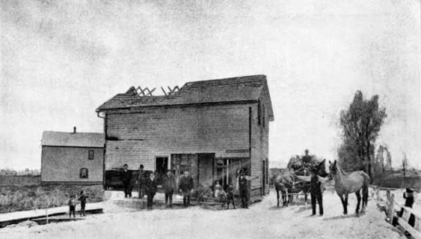
A group of men dressed as wild Indians set fire to the toll house one night in the spring of 1889. The plot to burn down that toll house was hatched in a saloon at Milwaukee and California. Farmers would stop in the saloon and over several steins of beer grew unhappy about being separated from their hard-earned money at Snell's gates only a few yards away at Milwaukee and Fullerton.
Both the Elston Plank Road and the Northwest Plank Road on Milwaukee continued to operate until 1889, when the Township of Jefferson was annexed by the city of Chicago. Indignant farmers staged a modern version of the Boston Tea Party — organized bands of fake Indians swept down upon both plank roads, chopped down the toll gates, and built great bonfires as a token of their Declaration of Independence from paying a toll for the right to travel on these great highways.
Unsolved
The Murder of Amos J. Snell
Amos J. Snell, the millionaire real estate owner and acknowledged wealthiest land proprietor on the West Side, was shot dead in the hallway of his brown-stone residence at 1326 West Washington Blvd. — at the northwest corner of Ada Street and Washington Boulevard — on Wednesday morning at about 2 o'clock. The murder was described as the "most sensational ever committed in Chicago."
Snell died from shock and hemorrhage caused by pistol shot wounds. Over 2,000 people were reported to have attended the funeral held within the library at his residence. After the funeral, over 100 carriages proceeded to Rose Hill Cemetery for the burial. Mr. Snell left a wife, Henrietta, two daughters, and a son. He did not leave a will.
Police arrested William B. Tascott on his deathbed at the Cape Nome Gold Diggings in Alaska in 1889. But 21 years later, James Gillan, labeled a "professional crook," confessed on his deathbed that he, not Tascott, had killed Snell while burglarizing his home. Some authorities still consider the case unsolved.
The Legal Aftermath
After Snell's death, the city of Chicago — which had extended its boundaries into areas containing parts of the road — began to tear down the toll gates because toll roads were not permissible in the city. Snell's heirs moved to secure his estate, particularly some 400 real estate properties and the valuable toll roads.
The Illinois Supreme Court ruled that the authority to collect tolls was a life estate — it could not be inherited. Snell's heirs appealed all the way to the U.S. Supreme Court, which in 1894 upheld the decision. Milwaukee Avenue has been a free and untrammeled road ever since.
Primary Source
Barry A. Fleig, Chicago & Cook County Cemeteries — A Historical & Contemporary Resource, August 5, 2024. chicagoandcookcountycemeteries.com